 Español
 English
Fortress of Sierro / Hisn al-Zuerro
Reference: AL-CAS-184
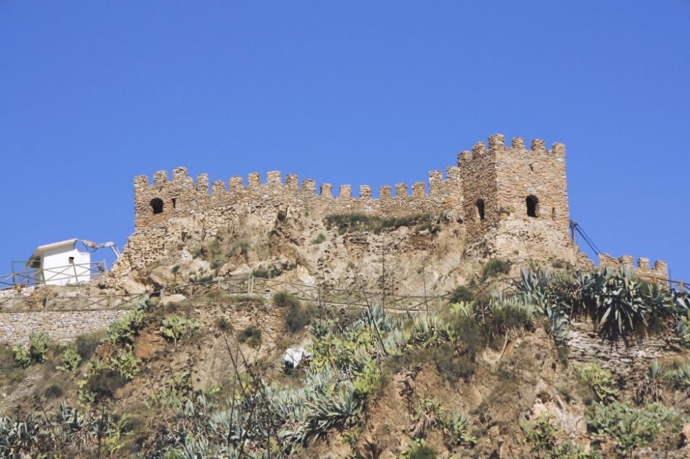
Corresponds to the IX-XIII centuries. Located on the top of the farmhouse with the role of shelter and urban citadel. It emphasizes its prominent height and its wide visibility on the territory. It is a medieval castle-fortress of Berber Islamic style. It is located in the highest part of the inhabited nucleus, rising over the Boloyunta river (Arabic name of the Sierro river) about 300 meters. The ruins of a fortress with a tower, square and solid, are conserved, controlling the valley of the river and with the tower-minaret of the church-mosque a few meters below the tower. The fortification is very eroded and the vestiges that remain are discontinuous elements of the wall with two concentric defensive perimeters, a tower, two little projected towers to the outside, a side door and a cistern. From it you can see Somontín, Lúcar and Urracal, the upper part of the Almanzora valley. The great tower dominates the entrance to the valley and its access road; on the southwest, the foothills of the Sierra de los Filabres and the upper Boloyunta valley. Andalusian construction completed in the Almohad period (12th century), with elements and Almoravid influences.
Situation
The nazarí castle of Sierro is in the town of the same name, province of Almería.
History
In the Upper Valley of the Almanzora there are important castles or hussün, the oldest one of Tíjola la Vieja (9th century), cited by al-Hayyan and al-Idrisi. This region had abundant Muladí and Mozarabic population, emigrated from cities and fields to high and safe areas, fleeing intolerance after the Muslim invasion. They had frequent fights with the central power of the Cordovan emirate and they are organized with a tower or fortification protecting every farmhouse. Until 1125, date of departure of the majority of the Mozarabic Almanzora with Alfonso I of Aragon, coexist with the Berber population. There are abundant place names in the Libros de Apeo, as the same word Sierro, Roman and Mozarabic place-name of Serro, indicates us abundant Christian population.
The castle of Sierro traces its origins to the pre-Islamic period. The hypothetical reconstruction of the original defensive system is based on the analysis of its location, materials and constructive techniques used, plant and elevation. The dating of the group is based on parallels established with similar structures of the Gothic and Emiral period in Peninsular Islam.
In the area of the Filabres the density of strengths is important. Ibn al-Jatib gives a detailed account of the agglomerations of the Filabres and Alto Valle del Almanzora. Ibn Hayyan in 913 relates the surrender of Ubayd Allah ben Umayya ben al-Saliya to Abd al-Rahman III al-Nasir. Umayya gives him all his castles and bastions, of the region, which were close to a hundred, among them the nearby fortress of Ragasana in Tíjola la Vieja
In the mountain valleys the fortified settlements have the same scheme. The castle with its farmhouse is located at the head of the narrow valley that goes down to the river Almanzora, to protect itself from the incursions of Muslims or Christians, especially in times of harvest.
The Sierro fortress has two defensive circles, one lower and one superior. The lower circle of stone without mortar with topographical distribution and a large tower reminds the ancient castrumromanos and godos. The upper circle seems to correspond to emiral beginning and Almohad ending.
The hisn de Sierro is located at the top of the farmhouse with the role of refuge and urban citadel, given its continuity with the high-rise area. The medieval farmhouse of Sierro is grouped around its hisn, a fortress that still dominates the entire valley. The castle is at the top of the hill, the place is totally strategic to control the wide cultivated valley watered by the waters of the Boloynta. It emphasizes its prominent height, its wide visibility on the territory, that could give warning to all the population in case of attack or threat. It is organized in a double enclosure, with a superior refuge in the center of the castle. The fortress is a topographic plant, adapted to the terrain, creating angles for greater defense of the same, divided into two lower and upper terraces. In the back it is inaccessible due to the height and slope of the hill, currently in this area an access ramp has been built.
In recent reconstruction works have been found ceramics, iron and lead slag, weapons, coins and Almohad weight of the ken of Jaén.
We can corroborate the pre-Islamic and emiral dating of the circle or lower stone fence. The wall or near superior is of tapial (tabiyya), realizing a serpenteante circuit with a massive tower until the adarve and a camera accessible from this. Constructive signs of Almohad identity on a primitive Roman Iberian fence (9th-12th centuries).
Description
Military architecture
The term hisn (castle or fortified citadel) designates a complex complex, territorial and social defined by the jurisdiction exercised by the hisn over the inhabitants of the area. It is located in a high place, on the top of a little accessible hill, constituted by a solid enclosure that circulated it and behind a peak cut (northwest). The enclosure of the fortress encloses a restricted space with no more income than a side and half hidden door of solid sheets lined with iron plates. This enclosure only contains a few permanent installations: cistern for rainwater, storage of arms and food reserve, several elementary lodgings for the guard and the tower. Below and outside the building begins the suburb with artisans and merchants and a mosque of modest dimensions. In case of warning, the population of the suburb is enclosed in the redoubt by moving their personal property.
The fortress of Sierro is a medieval castle-fortress, of Islamic style. Corresponds to the so-called fortress of farmstead with two concentric defensive circles. A first elevated circle of stone and above it an upper bastion with a fence or simple perimeter wall of rammed earth and a square tower that protects the entrance in a bend. The military architecture is represented by the remains of a castle and a cistern in the upper enclosure. It is located in the highest part of the inhabited center, southwest of the town, rising over the Boloyunta river about 300 meters and 790 meters above sea level. Its surface has dimensions of about 800 square meters and a diameter of 25 to 40 meters, extending along the peak of the hill in southeast-northwest direction (120º SE – 270 / 300º NW) from the tower to the current access ramp.
Walls and tower
We can see the ruins of a fortress with a square tower, massive up to the adarve, with a large square top chamber and a rampart fence surrounding the upper enclosure. The castle controls the valley of the river and the tower-minaret of the church-mosque a few meters below the tower and on your left from it. The fortification is very eroded and the vestiges that subsist are scarce: discontinuous elements of the two fences with two concentric defensive perimeters. In the upper a large tower, two little towers projected to the outside, a side door and a cistern. The fortress has a topographical distribution of the walls, with a fence cloth in sawed form.
The fortress of Sierro recalls that of Tíjola la Vieja, there is abundant archaeological material, ceramics and abundant iron slag (chronology from the 12th to the 15th centuries). The two defensive perimeter circles formed by the remains of the two walls are separated by a corridor of one and a half to five meters, wide, depending on the places. The upper fence is conserved with a height of 1-6 meters by 60 meters in length, in pieces of one to four meters in length and from 0.60 meters to 0.80 meters in width, built directly on the rock of the mountain.
The walls of the lower enclosure are made of stones, slabs and gravels, calcareous, siliceous and local shale unattached or sparsely joined with mud mortar, resting on the rock without foundation. The rocks are aligned and arranged with more or less regular stone songs. The construction of the walls is similar in the castles of the Filabres and they recall the castles of the Moroccan Atlas. They follow completely the form of hill.
The fence of the upper enclosure is tapial. We can see first a curved wall following the wall of the mountain, then a large square tower and then a walled structure in a dented form to lean on the natural shape of the mountain.
About 5 meters from the north peak of the fortress, on the interior perimeter, we find an entrance of 2 meters wide, parallel to the interior wall, concealed and with access from the lower adarve, oriented 90º east. This door, in turn, is typical of the Almohad fortresses, in a place not accessible, not visible, difficult to locate and easy to defend, with a corridor, straight 5 meters and then with a 180º curve that makes the assault difficult.
The upper defensive wall of Tabiya, about 80 meters, surrounds the highest part of the castle. In the outer perimeter circle of stone without mortar, of about 110 meters, there are the remains of a large square tower in the area that dominates the entire valley, at 120º southeast orientation. These square towers are particularly typological in the Sierra de los Filabres, either forming part of fortresses (Velefique, Bacares, Benitagla, Benizalon, Old Chercos, Tahal) or of farmhouse towers (Alcudia, Benimina de Benizalon) The quadrangular tower ( 5.75 x 4 meters) has a height of 14 m. on Castillo Street, it is built of stone without formwork
The floor of the tower of the upper enclosure built on the adarve of the lower one is eight meters high on the outer perimeter and is located in front of the tower of the church. It is built with Muslim formwork or tabiyya. The height of the rocks is 0.76 m. It is a massive tower, full of stones and earth, stands out above the rest of the fortress and is practicable from the castle with a large square chamber. From here you can see Somontín, Lúcar, Urrácal, the upper part of the Almanzora valley and the Sierra de Lúcar. The great tower dominates the entrance to the valley and its access road; on the southwest, the foothills of the Sierra de los Filabres and the upper Boloyunta valley.
The reservoir
The Castle conserves a well of rectangular plant with half barrel vault slightly lowered, with 6 meters of length in plant and 0,55 meters of diameter in the opening of superior access or luminary. It is eight meters in a straight line from the tower of the fortress, on the upper terrace, at the top of the hill, excavated on the cliff. The vaulted cistern is lined with lime and almagra that makes it waterproof. Its location at the upper end of the walled area prevented private supply. It is an underground cistern with a rectangular hole or hole for the breathing of water.
The cistern guaranteed the water to the inhabitants of the fortification in case of siege, it is part of a thousand-year-old Mediterranean tradition, as a place for water storage. It is a fundamental part of the fortress for the supply of troops, population and passers-by. The cistern or cistern is always a vaulted nave, without access stairs and with an upper port for water extraction and ventilation. These reservoirs are in many cases the only vestiges left standing in a fortress, farmhouse or cortijada. It is made of concreted tapial (ninth century).
The maqbara
On the southwest side, next to the fortress, on the lower perimeter, next to the top of the mountain, was the maqbara or cemetery. It has remained as such until 1935. It has recently been totally demolished along with the outer perimeter wall for the construction of a lookout.
State of conservation
In a state of consolidated ruin. There are only a few vestiges of the walls, towers and cistern and on these the fence has been reconstructed using the same rubble stone.
Protection
The Castle of Sierro was declared of cultural interest with the category of Monument (code: 40840002) and protected as a General Catalog of Historical Heritage entitled “Protection of Spanish Castles” by decree in the B.O.E. of April 22, 1949 and later Monument or Property of Cultural Interest on 25-6-1985, by Law 16/1985 on Spanish Historical Heritage. In 1993 the Junta de Andalucía granted special recognition to the castles of the Autonomous Community of Andalusia.
Under the protection of the generic Declaration of the Decree of April 22, 1949, and Law 16/1985 on the Spanish Historical Heritage.
Visits
It is open access.
Surroundings
More information about the municipality of Sierro and about the province of Almería in Monumentalnet (www.monumentalnet.org).
Books and publications
- Castles of Spain (volume I). VV.AA .. Editorial Everest, S.A. León, 1997. (Pg. 82).
- Sierro, memory of a farmhouse. Alberto Castellón Sánchez del Pino.
Comments 0